![](/images/other/stat-length.png)
![Tour Wandern Δημοτική Ενότητα Κυθήρων - Vers le phare de Moudari - Photo](https://media.geolcdn.com/t/1900/400/ext.pjpeg?maxdim=2&url=https%3A%2F%2Fmedia.geolcdn.com%2Ff%2F150bba5e-af3a-4a6a-8804-bd93215813a2.jpg)
Vers le phare de Moudari
LBarel
Benutzer
![Länge](/images/other/stat-length.png)
![Maximale Höhe](https://static1.geolcdn.com/siteimages/upload/files/1508320355ic_sort_altitude_max_24dp.png)
![Positive Höhendifferenz](https://static1.geolcdn.com/siteimages/upload/files/1508320355ic_sort_den_pos_24dp.png)
![Km-Effort](/images/other/stat-length.png)
![Min. Höhe](https://static1.geolcdn.com/siteimages/upload/files/1508320355ic_sort_altitude_min_24dp.png)
![Negative Höhendifferenz](https://static1.geolcdn.com/siteimages/upload/files/1508320355ic_sort_den_neg_24dp.png)
![Boucle](https://static1.geolcdn.com/siteimages/upload/files/16400158638029165_repeat_loop_refresh_sync_direction_icon.png)
![Wandern](https://static1.geolcdn.com/sitytour/trail-icons/101.png)
2h10
Schwierigkeit : Medium
![Scannen Sie diesen QR-Code, um die Tour in der SityTrail-Anwendung zu öffnen](https://capi.geolives.com/qq0zvz2zws4bq2lad0pu/sitytour/trails/2926868/qr.png?size=200)
Kostenlosegpshiking-Anwendung
Über SityTrail
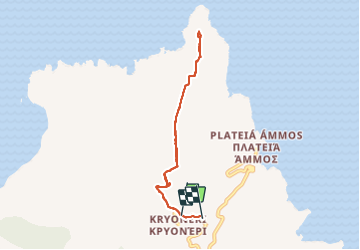
Tour Wandern von 7,7 km verfügbar auf Attika, Regionalbezirk Inseln, Δημοτική Ενότητα Κυθήρων. Diese Tour wird von LBarel vorgeschlagen.
Beschreibung
Un aller-retour de Kryoneri vers le phare de Moudari au nord de Cythère. Il existe de vrais chemins de randonnées que nous avons croisés régulièrement, mais ici il s'agit de routes non asphaltées larges et très praticables qui permettent de se concentrer sur le paysage plutôt que sur ses pieds. Très agréable balade.
Ort
Kommentare
Touren in der Umgebung
![Tour Zu Fuß Δημοτική Ενότητα Κυθήρων - M41 Mylopotamos Trail (long loop) - Photo](https://media.geolcdn.com/t/375/260/ext.jpg?maxdim=2&url=https%3A%2F%2Fmedia.geolcdn.com%2Ff%2F2f73411d-c491-4617-b6e1-53059594d683.jpeg)
![Zu Fuß Zu Fuß](https://static1.geolcdn.com/sitytour/trail-icons/100.png)
Zu Fuß
![](/images/other/stat-length.png)
![](https://static1.geolcdn.com/siteimages/upload/files/16400158638029165_repeat_loop_refresh_sync_direction_icon.png)